
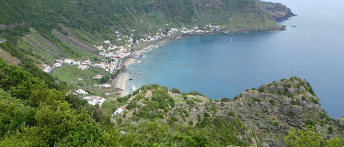
It was love at first sight with Santa Maria. We’d arrived in the dark, so we had no idea what the land around us would look like. When we woke in daylight and got our first view of the island, it was beautiful. We were anchored in a wide bay with a curve of golden sand in the middle and flanked by high cliffs. Directly beside us, loomed a sheer wall with a water carved path running down it. The waterfall was dry, but it still looked very dramatic. Looking upwards, green fields topped the island, rising to the tree covered peak. I knew I was going to like it here.
We headed to the harbour and berthed temporarily along the hammerhead pontoon before moving to a pontoon further in. The harbour has finger berths with a decent width between them. Both spaces between two fingers were empty when we entered which made it much easier for us. We would have to reverse out, but we’d deal with that when it happened.


Vila do Porto
Once we’d cleaned and tended to Emerald’s needs, we stopped late afternoon for an explore of the town. Vila do Porto (Harbour Town) perches high up between two river valleys, fronted by a fort from the days when piracy was a problem. The town is narrow, only three roads wide but long, spreading far uphill in a straight line.
The whitewashed buildings with their unusual chimney stacks look very sturdy, being made from volcanic stone. Along the main road were various bars, cafes, restaurants and shops. However, at 4pm everything was quiet. We found the supermarkets and replenished our stores.


A Tour Around the Island by Bus
The bus timetable took a bit of working out. There’s an app but elements of it don’t work, and a website. However, the website was best as it has a real time bus tracker, which we found incredibly useful.
A little after midday, a bus sets off to circumnavigate the east side of the island. Our plan was to take it to its end point and walk back to the harbour from there.
The occupants of the bus were a mix of visitors like us, and locals with their shopping as there are few shops in other parts of the island. The bus set off towards the centre of the island, confusingly doubled back on itself, then struck out north. We were happy looking at the views of the pastoral landscape with fields of grazing cows, plus a few sheep. Santa Maria has its own melon variety, and we saw some private allotments but no fields of crops were visible other than a few hay bales.
The route took us along the flank of the highest peak, Pico Alto (the imaginatively titled, high peak), from where we admired its tree covered slopes. Around the east side was more rural loveliness, dotted with cute, whitewashed villages. We passed through tunnels of tall, straight cedars and avenues of leafy sycamores. Plus, lining the roads, the ubiquitous hydrangeas that always remind me of Cornwall.
Finally, an hour or so later, we arrived at the end of the route which was a random place on a road far from groups of houses. I’m sure there’s a reason for it to be there, but it wasn’t obvious.

Coastal Walk Praia Formosa to Vila do Porto
Several people recommended this walk to us. It forms part of the first stage of the round the island walk, but we did it in reverse.
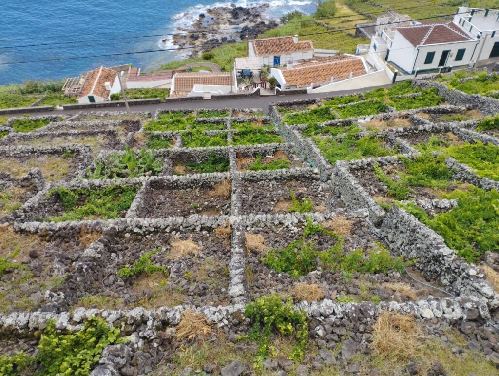
Dry stone walls surround the fields on the island. However, what makes them unusual is that each field is separated from its neighbour by a 2m wide gap creating a network of tracks. I guess they’re for easily moving livestock around rather than having to take them through many fields. For hikers, they create opportunities for exploring by foot.
The path we were on led down to the beach at Praia Formosa, a curve of soft, golden sand. It was quiet on the day we passed by. A food truck tempted us over with its bright colours, we expected ice creams but were pleasantly surprised to find it sold samosas.
From the beach, the path then goes steeply up the road. When the road turned inland, we took a turning onto a grass covered track between fields. There’s an option here to take a cliff edge route or to stay inland along the tracks. The cliff route is not good for those with vertigo.
Further along the coast path is an old lime quarry that is easy to look inside. The miners used the same technique that I’d seen on Ilha do Cal in Porto Santo. The lime is quarried out, but every so often pillars of rock are left in place in order to support the roof. It’s not a bulletproof method as in Porto Santo a roof collapse killed several miners. With this in mind, I entered gingerly, had a quick look around before returning to the safety of open sky.


Paul to Anjos
The round island bus only runs twice a day, however there is a more regular route between the swimming areas of Praia Formosa and Anjos.
Anjos
Anjos is located on the north west side of the island. It is another place where once again our path crossed that of Christopher Columbus. He stopped to take shelter from a storm in February 1493 in the bay on his way back from the Americas. Initially, his visit didn’t go well, but eventually it seems diplomacy smoothed the waters.
There is a ruined archway that dates from the chapel that was there at the time, along with a very big statue of the man himself.


The Walk
Following a ten minute journey, we left the bus at Paul, and set off down a country lane, passing a European Space Agency satellite tracking station. The road was very quiet, and only one car passed us whilst we were on it. We stayed on the road to visit the Barreiro da Faneca – the “red desert”. The land is clay and has formed a red colour, best seen when contrasted against a blue sky.
We backtracked to follow another section of the round island walk. Leaving the road, we took a grassy track leading gently downwards. On one side of the path was a green valley with a stream gently burbling away at the bottom. On the other side, but mostly hidden from view, were high cliffs straight down to the sea. Occasionally we caught a glimpse along the way, but the best views were being saved for later.
The route headed down to the stream where we crossed it twice. Next it took us out along the Punta dos Frades headland, behind which Columbus had sheltered. The walk saved the best for last, as the views here along the north coast were stunning.
The last part of the walk lead us down to the village via a gravelly path, a bit steep in places, but thankfully short. We had a short wait there for the return bus, enjoyed with a cold drink overlooking the natural swimming pools.


Scootering Around the Island
The bus allowed us to explore parts of the island, however there were other areas that needed alternative transport.
Hiring a car during July was not going to be possible, unless we wanted to spend an obscene amount of money. We could have hired a taxi to drive us around, but there was another alternative – to hire a 125CC scooter. We’d had to make the booking in advance due to limited availability and had chosen a day with what was forecast to be good weather. Lesson learned – the weather here changes so quickly that even the next day’s forecast might not be right.
As it was, the day started dry but with a strong southerly wind. Our first destination was to the top of the island. As we left Vila do Porto, we could see wispy clouds straggling around Pico Alto, but the top was still clear. Unfortunately, in the short time that it took to get there, the cloud built, driven by the moist, south wind. Still, we enjoyed riding up the road to the top, admiring the rust red cedar trees along the way.
From the carpark at the top, there are a few steep steps to the viewing platform at the highest point. Trees share the peak with a forest of masts which do somewhat detract from the view. Well, what little view there was for us anyway. We had a few, brief glimpses of the island below, but mostly we saw cloud. We would have to come back on a clearer day.


Sao Lourenco
As we headed back down, we descended out of the cloud layer. Then, as we zigzagged around the tight bends down to Sao Lourenco, the sun came out.
Sao Louenco is a small village in a stunning setting at the bottom of a steep sided bowl. Square plots of land have been created on these sharply sloping sides. The plots are currais, built for cultivating grapes. Each plot is surrounded by a low stone wall, with vertiginously steep steps for access.
A lovely golden, sandy beach joins land to sea. There were two boats anchored and we subsequently vowed to bring Emerald here if the weather allowed.

Maia
Unfortunately, the weather situation didn’t stay the same as we headed back up the cliff and continued on to Maia. The blustery wind hit us dead on and we were soon travelling through patches of fog.
With the cloud still swirling around us, we decided to park the scooter at the top of twisty road down to Maia and walk the rest of the way down. Once below the cloud level, the sky brightened up and we and got a closer look at the currais. We walked through the sleepy village to look at the Cascata de Aveiro. It’s billed as the highest waterfall in Portugal, and despite there being only a trickle of water, it was stunning. A motley crew of ducks and geese paddled around in the pool that has formed at the bottom of the falls.
On the way back up the hill, I took a detour out to the Farol de Goncalo Velho lighthouse. Even on the steep sides of this promontory, the land has been used for growing grapes.


Back to Pico Alto, This Time by Foot
The cloud spoilt our view on our first visit to Pico Alto, so I was determined to go back. This time by foot. We caught a bus to Almagreira, and joined the PR06 hiking route.
It is a fantastic walk which took us through beautiful forests, where in places it felt like the land that time forgot. We passed through a cut with earth walls, where the tree roots had grown down the outside. With it’s high walls and tree canopy overhead, we could definitely imagine the little folk living in this secret, wild place.
However, there is a lot of up. But the scenery was so lovely it distracted us from our complaining legs. And the reward was that we got to see the whole of the island from the top this time.
At the peak I spent a while turning circles spotting landmarks. We also spent a sombre few minutes at the memorial in which 144 people died where a plane crashed into the top of the peak.
From there we headed between trees along a ridgeline before curving back down. Finally, a gravel track took us to the road and a ten minute wait for the bis back to Vila do Porto.


Beer, Burgers and Melons
Cows are everywhere in the Azores, we’ve been told they outnumber people on most of the islands. In Santa Maria they are bred for meat, in the other islands they’re mostly for dairy.
On an evening out we chose to eat at a restaurant called A Travessa as their Facebook page had tempted us with pictures of delicious looking food. The clincher however was that it sold the locally brewed beer. And, not only sold it, but the owner of the restaurant is also the brewer. So, we had a good chat about beer. The raspberry ale was fantastic, with a blast of sweet fruitiness contrasting against the bitterness of the ale. Colin had a traditional IPA which he thought was very good too.
As well as cow products, the island also grows its own variety of melon. It has a very lovely, sweet flavour, due to the high soil fertility in which it is grown.


It Was Love at First Sight With Santa Maria
My initial feelings were spot on, I absolutely loved Santa Maria.
Most boats that came into the harbour only stayed a few days. I guess with the Azores covering such a large area and with limited time, most people want to get on to the other islands.
We stayed 18 days and I would happily return. The people we met were so warm and welcoming, we were given so many friendly waves on our explores. On our walks we mostly had the paths to ourselves, which was lovely when compared to the pictures of overcrowding that we see in tourist hotspots. Perhaps it’s a good thing that this 10 miles by 5 speck in the Atlantic remains an outlier to preserve its charm.
The Social Media Bit: Want to Follow Us?
Thank you for reading this far, we really appreciate it. If you’ve enjoyed our site or found it useful, please consider a donation via the DONATE button below. We’re grateful for anything you can spare!
If you’d like to follow us on other social media platforms (Facebook, Instagram and YouTube), you can do so by using these links:
Or use the link below to track our voyage on NoForeignLand.com.
And finally, you can sign up to receive email notifications of new blogs using the subscribe box at the bottom of this page.
Thank you from Nichola & Colin