
15th September: It was decision time…. Should we sail down west Sardinia or the east coast? During the windy day in Cala Taura, we had made a ‘back-of-a-fag-packet’ plan to get us to Sicily. My preference was to sail the west coast as this was a new cruising ground for us and a shorter distance to Sicily, but there are fewer places to hide from bad weather than on the east.
We scoured the many weather forecasts. The weather looked to be on our side, at least for the short term, with southerlies blowing up the east coast which would make progress difficult. Westward-ho!

We Chose West Sardinia
There was still a swell rolling from the west making our motion a little queasy, but as the wind was when we headed north, the Bonifacio Straights winds were benign for us. A light westerly breeze allowed us to sail languidly for a few hours before our slow progress forced us to motor-sail if we wanted to be in before dark. And dark was coming noticeably earlier these days.
We stayed well off outside the Parco Nazionale dell’Asinara before coming in to anchor in the shallow, sandy lagoon between Isola Piana and La Pelosa on the island of Sardinia. There was plenty of space and the sunset was creating a splendid display for us.

Asinara Nature Park
To visit the Asinara Park, yachts must pay to pick up a mooring buoy. Anchoring anywhere within the park limits is not allowed. We tried to circumvent this by dinghying over from where we were anchored, we’d then hire bikes for an exploration. But on our way, a RIB passing in the other direction hailed us. The man kindly explained that we couldn’t motor through the park and that our best options were to take an authorised boat trip or pick up a buoy, preferably at Cala Reale as that spot had the better options for exploring.
La Pelosa
So back to Emerald, we called up the park and booked a buoy for the next day. We then explored around La Pelosa instead. It was busy ashore, it being a sunny Sunday, the shallow waters looking a gorgeous blue in the sunshine.
In the evening two dolphins came in to feed. Small boats were chasing them around and getting far too close, so the dolphins left. After dark, we heard some blowing and splashing and wondered if they’d returned to fish and eat in peace.


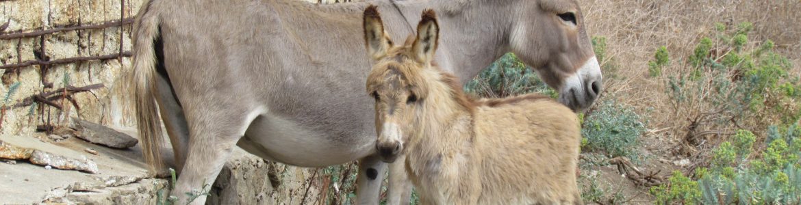
Donkey Spotting
We were awoken at 7:30 the next morning by a stupid boat sounding its horn to let everyone know it was leaving. Like anyone cared! But it got us up and away early up to Cala Reale to make the most of our time on the buoy. The skies greyed over on our way there and just after picking up a buoy, the rain arrived. Donkey spotting would be delayed for a while. Or so I thought…. I heard some braying from ashore and there was an albino donkey strolling along. Colin reckoned we could leave now, but oh no, one donkey would not suffice.

An hour later, blue skies had returned and we headed ashore. A park ranger had been out to visit us and explained what there was to see. If we wanted we could tie up to the quay where electricity and water were available inclusive of our fee. It looked a bit shallow for us, so we stayed on the buoy. However, we used the pontoon to tie up the dinghy.
Ashore we found a visitor centre, toilets and some marked trails. And of course, more donkeys. Now you may want to skip ahead if pictures of donkeys do not interest you!

Walking the Memory Trail
We followed the signs for the Memory Trail, heading west towards open land. As well as being famed for its donkeys, from whom it gets its name, the island has an interesting history. At times it has been a quarantine, WWI prison camp and most recently a high-security prison housing mafia bosses. Now it has now been returned to nature with the creation of a wildlife and marine park. However, the remains of this often troubled history can be seen through the ruined buildings, memorial parks, and museums dotted around the landscape.

Along the trail, we came across Campo Perdu, a stables block that was once part of the agricultural penal colony. Larger groups of donkeys and horses were gathered here, with park staff tending to those donkeys that needed a bit of extra care.


Cala Olivia
For the afternoon, we took the local bus to the village of Cala Olivia. The bus runs from there to Fornells at the southern end of the island and back several times a day and a ticket for €5 lasts all day. We were catching it on the last day of the season.
Cala Olivia was an old agricultural prison and the administration area for the other prisons on the island. At the top of the village is a former prison block that now serves as a museum. The cells are set up as they would have been when prisoners occupied them and there are displays on their day to day life. Next door is a playing field with skeletal goalposts and beyond a maximum-security area with rusting watchtowers dotted along its high walls.


We were treated to a lovely sunset that evening, and the peace of the island cocooned us. An occasional donkey bray was the only sound that broke the silence.


Walking the Way of the White Donkey
To make the most of our time in the national park, we got up early the next morning for a walk along the ‘Way of the White Donkey‘. It took us past another agricultural penal colony and to a tower on the headland.


Here Comes the Rain
We arrived back at Cala Reale just as the first drops of rain fell. If there was an Olympic sport for starting the dinghy and casting off we would be strong contenders for winning gold that day. The drops were becoming more frequent as we made it back to Emerald. We got the dinghy stowed and us inside just before the heavens opened.
With the weather as it was, there didn’t seem much point in staying another day; however, there would have been plenty ashore to occupy us had it been dryer. Perhaps a bicycle down to the prison block at Fornells or some more animal spotting. There are also cows, wild pigs and goats living on the island but we hadn’t seen any yet. As it was, we dropped the mooring lines between the rain showers and headed back to the anchorage off La Pelosa.

South to Porto Conte
We had to continue south as the forecasts were showing some nasty winds for the next week. Under grey skies, we set off through the narrow passage between Piana and Asinara islands, following the transits. Out beyond the land, it was hard to see where the sea ended and the sky began; however, an obliging wind set up and pushed us south at 5kts.
As we approached the impressive cliffs off Capo Caccia, the wind became gusty and a thunderstorm popped up ahead of us. However, by going in close under the shelter of the towering cliffs, we found flat calm water and no wind, perfect to drop the main. By the time we’d done this and turned into the large bay of Porto Conte, the storm had trundled off inland and all we caught was a bit of rain on its trailing edge.
We anchored off the marina at Porto Conte, feeling rather lonely. There wasn’t another boat around.

Exploring Porto Conte Nature Park
The unsettled weather of the last few days had passed and we were grateful to see a bright, sunny morning when we looked outside the next day. We took the dinghy ashore and tied up where a Marinero asked us to call into the office. There they wanted €10 just to leave the dinghy! How much? Perhaps this was the ripoff Sardinia we had read a lot about but fortunately not encountered so far. But what else could we do, there was nowhere else to go.
So we paid up and walked a short way down the road to the entrance to the Porto Conte nature park. Here they wanted €3 per person to enter. At least a nice man gave us a map and a description of the park for our money.
There were several marked trails and we had a good wander around to make the most of our fee. The coast path took us out to a headland, passing some pretty coves for swimming along the way.

WWII History
As well as stunning views across to Capo Caccia, out on the Punta del Giglio headland were some WWII barracks and gun emplacements. They had excellent views from high up on the cliffs, but thankfully never sank any shipping. Judging by the drawings and doodles still visible on the walls, the sailors stationed here had a lot of time whilst waiting for something to happen. However, the only action occurred here was in 1941 when two British ships snuck in under darkness and opened fire on the battery. Because he hadn’t received authorisation from higher up the chain, the station commander didn’t fire back and the British ships got away unscathed.


Into the Forest
From the headland, we headed back inland and wandered off deeper into the forest. We didn’t see another person. Eventually, we arrived at a gate with a broken lock – perhaps this is the locals way into the park without having to pay. A well-stocked grocery store was nearby which meant we didn’t have to break open any tins from the emergency food supplies.


Cala Tramariglio – Shelter From the Wind
The wind arrived the next day with more north in it than forecast which created a short chop. Nothing uncomfortably in heavy hulled Emerald, but enough so that going ashore would be difficult.

However, stronger winds were due from the west; we were completely open to that direction so needed a better spot to hide them out. Across the opposite side is the bay of Tramariglio which looked good and with pontoons too – too shallow for Emerald but good for tying the dinghy.
As we got closer, we could see there were also moorings, several of which were empty and may provide a good backup if the holding was iffy, as many comments were saying on Navily. It took us two attempts to set the anchor, thankfully the second attempt held firmly.

The Cliffs of Capo Caccia
The anchorage was well placed for a walk up to the cliffs at Capo Caccia. The route is partly on the road alongside a holiday resort but it wasn’t too busy and after a while I was able to peel off onto a rough track.

After passing some pretty coves, the track turned steeply up and soon I was at the top, taking in the views across to Punta del Giglio. There are numerous caves pitting the headland, but the majority are closed due to erosion. The only one that can be visited is the Grotta di Nettuno. There’s just one downside to getting there via the Escala del Cabirol – 656 steps and a 100m descent cut into the cliffs.
The down wasn’t so bad, it was the ascent that was the killer! The steps are very well made. There is a wall to stop anyone whose knees give out, tumbling to their deaths to the churning waters below. And whoever designed them, put in plenty of rest spots for catching your breath and admiring the views. I found a great camaraderie amongst the people I walked up with. Despite our language differences, our body actions soon had us all laughing as we mimed collapsing from so many steps.


The Archimete Bar
As well as providing great shelter, Tramariglio had a popular little beach with the Archimete bar behind it. We visited for ice creams that turned into unfiltered bottles of Icnusas as we chatted to the friendly owners who also ran a dive and adventure centre. Lush grass surrounds the bar, which I enjoyed wiggling my toes through. It had been a long time since we’d seen such green grass. We had a pleasant few hours; little did we know we’d be back….
An Aborted Sail to Alghero
Our research into Alghero had uncovered information about a free quay amongst the harbour concessions. Being of a frugal nature, this sounded like a perfect fit for us, especially as we didn’t need water or power. So on a sunny, windless Sunday morning we picked up the anchor and set off for the 7nm trip.
When we reached the entrance to the bay, we met a F6 from the south. It hadn’t been forecast! But as it was only an hour to go we decided to plug on, hoping it was some kind of local wind anomaly that would disappear around the corner.
No such luck. Instead, it increased to F7 with short, choppy waves splashing over the deck and sprayhood. We plugged on, knowing from the wind direction that Alghero harbour would be sheltered from the worst of it.
At the harbour entrance, two RIBs approached us asking if we wanted a berth. We politely declined as we were going to the town quay. But! The concessions have laid out mooring lines along the quay with permission to charge if visiting boats use these lines to stern moor. There was an alongside space available between two yachts but no way near big enough for us to manoeuvre into, especially in the gusty wind funnelling down.
About, Turn
We grumpily turned around and left, briefly considered anchoring outside the harbour walls, but it would have been a long and soggy ride to get ashore by dinghy. Return to Porto Conte it was.
And of course on the return trip when we could have used the southerly to sail back, the wind disappeared.
Back in Tramariglio we tried to anchor but our luck had completely run out this morning. We were simply pulling the hook through a thin layer of mud on top of rock. We tried a different spot near to where we’d left from a few hours ago but same again, dragging through thin mud. Colin went in to swim out and look at what the anchor was doing as I reversed back. As he did so, a motorboat nearly ran him over despite all the waving and calling I was doing and the acres of space around us. And they had the cheek to gesticulate at us!
Despondently we pondered what to do now. Back to Alghero to pay for a berth? As we dithered, one of the yachts on the moorings dropped off and left. We dashed over and picked it up before anyone else could get it. Because knowing how everything else had gone that day, if we’d waited just one minute longer it would have gone!
A Mooring at Tramariglio
It was shallow with just 1m under us, but we could see three huge concrete blocks anchoring the mooring to the seabed. Strong westerly winds were due tomorrow so that would do nicely. The moorings were run by the beach bar and we could stay for €20 a night. We were sold.
I made the most of our spot with an explore ashore. The nature park map we’d been given a few days ago also showed the park extending around where we were. However, high, unclimbable fences and locked gates blocked any access with signposts telling me the entrance was 5km along the busy road. Instead, I settled for a stroll up to the ruined watchtower beside the bay and down to the ruins of the hotel resort on the other side.
After a day like that, we decided that beer was required to soothe our frazzled nerves. We returned to the beach bar for several medicinal, ice-cold Icnusas.


Alghero By Bus
The next day the wind really did blow. At the top of the mast, we registered 30kts but the water was only showing light ripples. With those three concrete blocks holding us, we felt confident to leave Emerald and visit Alghero by bus which passed close by the head of the bay.
There were no shops or kiosks at which to buy tickets, so the driver let us on without paying then dropped us off by a kiosk in the town to buy them, waiting whilst we did so we could get the tickets stamped back on the bus.
We enjoyed a wander through the maze of streets and along the walls of the old town, had lunch and stocked up on food for a few days. The wind was howling into the bay at Alghero although the harbour was well protected.


Confined to Boat Prison
After the previous few weeks of settled weather, autumn was arriving with a vengeance. We had a storm to deal with.
We would have happily stayed on the buoy at Tramariglio for a few more days, eating ice creams, drinking beer and wiggling our toes in the grass, however, rather than the wind being from the prevailing westerly direction, it was going easterly and would blow straight into the bay. On top of that, it was forecast to change overnight. On our return from Alghero we had to make a decision – should we stay or should we go? If we stayed it could get very uncomfortable with a chop and swell rolling in and an upwind slog in the morning to return to the anchorage off Porto Conte marina. We discussed it over ice cream and the sensible voice in our heads said go now. We waved a reluctant farewell to the safe haven of the Archimete bar and set off across the bay.
It had been deceptively calm in Tramariglio. Across the other side, we still had 25kts from the west and we wanted to set the anchor to the east ready for the overnight wind shift. It was tricky but we managed it. Colin went in for a swim to check the anchor; the sun was now hidden behind clouds and combined with the wind chill this was a heroic gesture to ensure our safety.
Day One
Colin was up at 6 am to check all was well. It sounded like the wind had arrived. I slept on to 9 am. Ahhh I do like our Rocna anchor! The wind blew strong from the east all day and the sky was overcast until early evening. Even with the wind genny going all out all day, our power generation suffered from the lack of solar, so we couldn’t watch tv to pass the hours of boat prison. So, I baked a cake (from a packet) and attempted to brush up on my Italian. After a few days of activity a day off felt good.
Day Two
Our second day confined to the boat started with a lovely, long lie-in. It was sunnier today so we were back to keeping up with our power usage. An Ulster fry, some music practise and playing with video editing helped day two of the windopolypse pass quickly.
Running South
27th September: With the strong winds having been from the east, the swell out to sea shouldn’t be too bad, so with that in mind and the hope of picking up the last of the offshore easterly to blow us south, we made a decision to get up early and make a run for it. We would decide with the 8 am weather update if we’d call into Bosa or keep going for Capo Mannu.
The winds provided as we hoped all the way across Alghero Bay then died. The forecasts updated and didn’t look great – a powerful mistral was due to blow hard from the west in a few days time, so we decided to keep going. The wind filled in from the north early afternoon and we were able to sail the remainder of the passage.
Capo Mannu / Cala Saline
The anchorage at Capo Mannu is a rare beast on Sardinia’s west coast, in that it provides great shelter from the north and northwest. Several large, sandy spots were clearly visible for us to drop the hook in.

After being onboard for the two previous days during the strong winds and a long day at sea today, my legs were twitching to get ashore for a walk. Colin dropped me off on a pontoon next to a slipway and I enjoyed the late afternoon sun as I followed a trail around the Capo Mannu headland past the two watchtowers that guard the landscape. It reminded me of cliff top walks in Cornwall.


The north side of the headland was the domain of the surfers with several interesting looking campervans parked up behind the beach.
Back aboard we watched the sun set with our clear view to the west and hoped for a green flash, but not today, there was too much cloud far out on the horizon.

More Running Away
Something had changed within us. Where just a few days ago we were happy to stretch out our summer, now we were itching to be tucked up in our winter berth. Perhaps it was the change in weather as we departed wearing socks and long trousers.
Like yesterday we managed an hour of sailing with the offshore wind before it died away. By midday, it was filling in from the north, a sea building with it. We motor sailed with the main out on a preventer as the genny would not stay full in the sea state.
There is a village called Buggerru on the stretch of the coast we were sailing down. I’d wanted to stop here four years ago for its name alone. The weather didn’t allow us to then and it wasn’t doing so now. A shame as the scenery looked very dramatic with cliffs twisting and falling into the sea. Buggerru we will try again for a third time, perhaps next year.


Quick Decisions Needed
We closed on our chosen anchorage at Masua doing nearly 7kts. 5 pm and two hours to sunset, 14nm to our next possible anchorage. We had to make a quick decision – was this a good place to stop?
A look through binoculars showed small waves breaking along the beach next to the anchorage. Decision made, we’d keep going. I really didn’t want an uncomfortable night rolling in a swell. We knew the next anchorage was well sheltered – around the south of San Pietro island, named by us as Cormorant Cove and the first place we landed when we sailed to Sardinia four years ago.

Finding a Calm Haven
We rode the swell south, keeping up our speed as we passed Carloforte, turned the corner to ‘Cormorant Cove‘ and were very pleased to see no other boats on our preferred part of the anchorage. Anchor down as the sun dipped behind the land, it was so calm you wouldn’t know it was blowing a hoolie just around the corner.


Cormorant Cove
The weather wasn’t giving us a break. Our first look at the forecasts for the next week predicted a lot of wind all over the Med. Way over in the Ionian, a medicane was developing whilst up in western France a mistral was forming and stretching its blowy fingers right down to Sardinia and across to Sicily. When that passed, the winds along the south coast of Sicily turned south-east, which would be right on our nose, and kept on blowing that way as far as the forecasts ran. We could ride the mistral across to west Sicily but might then get stuck there for who knows how long. If we didn’t leave Sardinia, we couldn’t see another window for crossing and most likely would have to go into Calasetta marina to find shelter.
We made a decision. We would leave tomorrow afternoon as the mistral built and be blown across to Sicily. What to do then would depend on the forecasts we would pick up off the Sicilian coast. We also had the SSB for obtaining weather updates. But when we tested it, we found a corroded cable running up the back stay. That settled what Colin would be doing for the afternoon.


The End of the Season
Faced with three days at sea, I took a chance for a leg stretch ashore and perhaps the last swim of the season. But there were jellyfish! Swim curtailed we prepared a BBQ to celebrate the last day at anchor of summer 2018.

Sail West Sardinia Info
North West Sardinia
15th September: Tizzano, Corsica to La Pelosa, Sardinia – 40nm
Anchored in 3.5m in the sand in position 40 57.932’N 8 13.441’E
A huge area of sand to anchor in, but there are some very shallow areas to watch out for.
A small harbour is on the mainland where the dinghy can be left.
Bars and restaurants along the shore and a small shopping mall out to the west has a grocery store.
17th September: La Pelosa to Cala Reale, Asinara Island – 7nm
Picked up a buoy in position 41 03.714’N 8 17.516’E 3m of water
We paid 42 euros for the night; this included water from the pontoon where we could tie up the dinghy.
Walks, history and donkeys ashore, but no supplies.
18th September: Cala Reale, Asinara Island to La Pelosa – 7nm
Anchored in 3m in position 40 57.977’N 8 13.173’E
Porto Conte
19th September: La Pelosa to Porto Conte – eastern side, off the marina
Anchored in 4m in position 40 35.821’N 8 12.853’E
Good holding in mud. We sat out 40 kts of wind from the northeast and east here.
Dinghy stowage in the marina, however, they wanted 10 euro to leave it there.
Despite there being a mast on the hill behind us, we found the internet to be very slow here.
The grocery store tucked away a few streets back from the main road was very well stocked and had lovely staff who gave us free cakes. Turn left out of the marina, then first right. There were several restaurants in the area too but the majority had closed already for the season.
A bus runs several times a day to Alghero – turn left out of the marina and the stop is outside the Porto Conte Hotel.
22nd September: Porto Conte to Porto di Tramariglio – 2nm
Anchored in 4.5m in position 40 35.489’N 8 10.324’E
23rd September: Aborted trip to Alghero, returned to Tramariglio and picked up a mooring buoy off the Archimete beach bar, 20 euro a night
24th September: Back to off Porto Conte Marina.
Anchored 3.3m in position 40 35.8’N 8 12.881’E
West Coast Sardinia
27th September: Porto Conte to Capo Mannu – 37nm (11nm sailed)
Anchored in 5m in position 40 01.736’N 8 23.783’E
Small jetty ashore, walk around the headland. Pizza restaurant along the shore.
28th September: Capo Mannu to Punta Nera (Cormorant Cove), Isola di San Pietro
Anchored in 7.5m in position 39 06.016’N 8 18.188’E
Beach and rocks ashore – outside the season, dinghies can be left on the beach. No supplies but a bus runs to Carloforte.
The Social Media Bit: Want to Follow Us?
If you’d like to follow us on other social media platforms (Facebook, Instagram and YouTube), you can do so by using these links:
Or use the link below to track our voyage on NoForeignLand.com.

And finally, you can sign up to receive email notifications of new blogs using the subscribe box at the bottom of this page.
Thank you from Nichola & Colin